-
Village 51.7843, -1.28954 0.82 kms (W) Wolvercote Oxford Oxfordshire South East England United Kingdom
-
Pub 51.78014, -1.2992 1.57 kms (WSW) Wolvercote Oxford Oxfordshire South East England United Kingdom
-
Village 51.76523, -1.28832 2.32 kms (SSW) Oxford Oxfordshire South East England United Kingdom
-
Village 51.76523, -1.28832 2.32 kms (SSW) Oxford Oxfordshire South East England United Kingdom
-
Bridge, Road Bridge, Tertiary 51.77955, -1.2998 1.63 kms (WSW) Oxford Oxfordshire South East England United Kingdom
-
Abbey, Archaeological-site 51.77835, -1.29994 1.7 kms (WSW) Oxford Oxfordshire South East England United Kingdom
-
Bridge, Road Bridge 51.75254, -1.27263 3.63 kms (S) City Centre Oxford Oxfordshire South East England United Kingdom
-
Administrative, Civil Parish, Village 51.77482, -1.3116 2.59 kms (WSW) Vale of White Horse Oxfordshire South East England United Kingdom
-
Administrative, Civil Parish, Village 51.80461, -1.30894 3.06 kms (NW) Yarnton Cherwell Oxfordshire South East England United Kingdom
-
Administrative, City 51.75201, -1.25785 3.91 kms (SSE) Oxford Oxfordshire South East England United Kingdom
-
Bridge, Railway Bridge 51.7471, -1.26704 4.28 kms (S) South Oxford Oxford Oxfordshire South East England United Kingdom
-
Administrative, Village 51.74548, -1.28458 4.42 kms (S) Vale of White Horse Oxfordshire South East England United Kingdom
-
Bridge, Cycleway, Foot Bridge 51.74682, -1.26066 4.4 kms (SSE) City Centre Oxford Oxfordshire South East England United Kingdom
-
Park 51.74548, -1.26362 4.5 kms (SSE) South Oxford Oxford Oxfordshire South East England United Kingdom
-
Island, University 51.75658, -1.24457 3.9 kms (SE) City Centre Oxford Oxfordshire South East England United Kingdom
-
Bridge, Folly, Primary, Road Bridge 51.74588, -1.2563 4.59 kms (SSE) South Oxford Oxford Oxfordshire South East England United Kingdom
-
Attraction, Meadow 51.74658, -1.25192 4.63 kms (SSE) City Centre Oxford Oxfordshire South East England United Kingdom
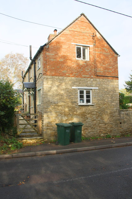
51.785,-1.27772 18/07/2021 Robin Webster CC BY-SA 2.0 0 kms (N)
51.78491,-1.27816 15/06/2019 N Chadwick CC BY-SA 2.0 0.03 kms (WSW)
51.786,-1.27843 15/06/2019 N Chadwick CC BY-SA 2.0 0.12 kms (NNW)
51.78567,-1.28409 09/10/2020 Ian S CC BY-SA 2.0 0.44 kms (W)
51.78469,-1.28541 09/10/2020 Ian S CC BY-SA 2.0 0.53 kms (W)
51.78433,-1.28556 09/10/2020 Ian S CC BY-SA 2.0 0.54 kms (W)
51.78487,-1.2857 11/07/2020 Stephen McKay CC BY-SA 2.0 0.55 kms (W)
51.78523,-1.28584 11/07/2020 Stephen McKay CC BY-SA 2.0 0.56 kms (W)

51.77565,-1.27686 02/01/2019 Roger Templeman CC BY-SA 2.0 1.04 kms (S)
51.77532,-1.28193 02/01/2019 Roger Templeman CC BY-SA 2.0 1.12 kms (SSW)
51.7752,-1.28209 02/01/2019 Roger Templeman CC BY-SA 2.0 1.13 kms (SSW)
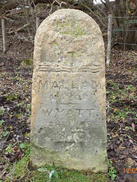
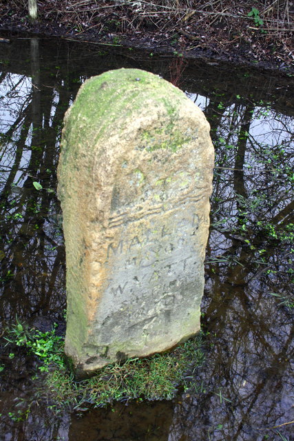
51.77517,-1.28208 01/01/1970 Milestone Society CC BY-SA 2.0 1.13 kms (SSW)
51.78426,-1.28875 09/10/2020 Ian S CC BY-SA 2.0 0.76 kms (W)
51.784,-1.29006 09/10/2020 Ian S CC BY-SA 2.0 0.86 kms (W)
51.78088,-1.29518 01/01/2021 Steve Daniels CC BY-SA 2.0 1.29 kms (WSW)
51.77005,-1.28854 16/06/2018 N Chadwick CC BY-SA 2.0 1.82 kms (SSW)
51.78107,-1.29576 01/01/2021 Steve Daniels CC BY-SA 2.0 1.32 kms (WSW)
51.78017,-1.29606 26/02/2021 Steve Daniels CC BY-SA 2.0 1.37 kms (WSW)
51.78134,-1.29633 26/02/2021 Steve Daniels CC BY-SA 2.0 1.34 kms (WSW)
51.78134,-1.29633 01/01/2021 Steve Daniels CC BY-SA 2.0 1.34 kms (WSW)
51.76988,-1.28941 09/10/2020 Ian S CC BY-SA 2.0 1.86 kms (SSW)
51.7655,-1.27861 01/01/1970 Des Blenkinsopp CC BY-SA 2.0 2.17 kms (S)
51.76953,-1.29058 16/06/2018 N Chadwick CC BY-SA 2.0 1.93 kms (SSW)
51.77865,-1.29725 26/02/2021 Steve Daniels CC BY-SA 2.0 1.52 kms (WSW)
51.76423,-1.27776 09/07/2014 Steve Daniels CC BY-SA 2.0 2.31 kms (S)
51.77495,-1.29614 09/10/2020 Ian S CC BY-SA 2.0 1.69 kms (SW)
51.77613,-1.29685 01/01/1970 Des Blenkinsopp CC BY-SA 2.0 1.64 kms (SW)
51.76389,-1.28096 09/10/2020 Ian S CC BY-SA 2.0 2.36 kms (S)
51.7638,-1.28038 09/10/2020 Ian S CC BY-SA 2.0 2.36 kms (S)
51.77739,-1.2977 20/10/2019 Steve Daniels CC BY-SA 2.0 1.61 kms (WSW)
51.77811,-1.29827 26/02/2021 Steve Daniels CC BY-SA 2.0 1.61 kms (WSW)
51.77685,-1.29814 07/06/2014 Wayland Smith CC BY-SA 2.0 1.67 kms (WSW)
51.77965,-1.29911 19/08/2021 Rob Farrow CC BY-SA 2.0 1.59 kms (WSW)
51.77658,-1.29815 09/10/2020 Ian S CC BY-SA 2.0 1.69 kms (SW)
51.77983,-1.29926 19/08/2021 Rob Farrow CC BY-SA 2.0 1.59 kms (WSW)
51.77974,-1.29926 09/10/2020 Ian S CC BY-SA 2.0 1.59 kms (WSW)
51.7628,-1.27923 09/07/2014 Steve Daniels CC BY-SA 2.0 2.47 kms (S)
51.78001,-1.2994 19/08/2021 Rob Farrow CC BY-SA 2.0 1.59 kms (WSW)
51.77686,-1.29858 09/10/2020 Ian S CC BY-SA 2.0 1.7 kms (WSW)
51.76253,-1.27895 09/10/2020 Ian S CC BY-SA 2.0 2.5 kms (S)
51.77974,-1.29969 19/08/2021 Rob Farrow CC BY-SA 2.0 1.62 kms (WSW)
51.76154,-1.27867 09/10/2020 Ian S CC BY-SA 2.0 2.61 kms (S)
51.76154,-1.27882 09/07/2014 Steve Daniels CC BY-SA 2.0 2.61 kms (S)
51.76036,-1.27739 09/07/2014 Steve Daniels CC BY-SA 2.0 2.74 kms (S)
51.7578,-1.27019 09/07/2014 Steve Daniels CC BY-SA 2.0 3.07 kms (S)
51.7578,-1.27004 09/07/2014 Steve Daniels CC BY-SA 2.0 3.07 kms (S)
51.75735,-1.27063 09/07/2014 Steve Daniels CC BY-SA 2.0 3.11 kms (S)

51.77699,-1.30626 21/02/2016 David Howard CC BY-SA 2.0 2.16 kms (WSW)
51.75618,-1.26949 09/07/2014 Steve Daniels CC BY-SA 2.0 3.25 kms (S)
51.756,-1.26978 09/07/2014 Steve Daniels CC BY-SA 2.0 3.27 kms (S)
51.75609,-1.26934 09/07/2014 Steve Daniels CC BY-SA 2.0 3.27 kms (S)
51.75591,-1.26964 09/07/2014 Steve Daniels CC BY-SA 2.0 3.28 kms (S)
51.75591,-1.2692 09/07/2014 Steve Daniels CC BY-SA 2.0 3.29 kms (S)
51.75573,-1.26921 09/07/2014 Steve Daniels CC BY-SA 2.0 3.31 kms (S)
51.75546,-1.26906 09/07/2014 Steve Daniels CC BY-SA 2.0 3.34 kms (S)
51.75865,-1.26162 27/11/2019 Steve Daniels CC BY-SA 2.0 3.13 kms (SSE)
51.75837,-1.26018 27/11/2019 Steve Daniels CC BY-SA 2.0 3.2 kms (SSE)
51.75747,-1.26019 27/11/2019 Steve Daniels CC BY-SA 2.0 3.29 kms (SSE)
51.75268,-1.27012 18/07/2021 Robin Webster CC BY-SA 2.0 3.63 kms (S)
51.77332,-1.30936 21/02/2016 David Howard CC BY-SA 2.0 2.53 kms (WSW)
51.77359,-1.30964 21/02/2016 David Howard CC BY-SA 2.0 2.54 kms (WSW)
51.75372,-1.2646 12/08/2021 David Hillas CC BY-SA 2.0 3.59 kms (SSE)
51.77369,-1.31008 21/02/2016 David Howard CC BY-SA 2.0 2.56 kms (WSW)
51.7587,-1.25554 27/03/2014 Marika Reinholds CC BY-SA 2.0 3.3 kms (SSE)
51.77531,-1.31078 21/02/2016 David Howard CC BY-SA 2.0 2.52 kms (WSW)
51.75531,-1.26008 27/11/2019 Steve Daniels CC BY-SA 2.0 3.52 kms (SSE)
51.75027,-1.27277 09/10/2020 Ian S CC BY-SA 2.0 3.88 kms (S)
51.75798,-1.25497 21/02/2010 Wayland Smith CC BY-SA 2.0 3.39 kms (SSE)
51.77469,-1.31195 21/02/2016 David Howard CC BY-SA 2.0 2.62 kms (WSW)
51.7746,-1.31209 07/12/2016 Roger Davies CC BY-SA 2.0 2.63 kms (WSW)
51.77505,-1.31223 21/02/2016 David Howard CC BY-SA 2.0 2.62 kms (WSW)

51.74918,-1.27206 09/10/2020 Ian S CC BY-SA 2.0 4 kms (S)
51.74918,-1.27192 09/10/2020 Ian S CC BY-SA 2.0 4 kms (S)
51.74882,-1.27236 09/10/2020 Ian S CC BY-SA 2.0 4.04 kms (S)
51.74882,-1.27192 09/10/2020 Ian S CC BY-SA 2.0 4.04 kms (S)
51.77361,-1.31298 07/12/2016 Roger Davies CC BY-SA 2.0 2.74 kms (WSW)

51.74855,-1.27106 09/12/2020 Roy Hughes CC BY-SA 2.0 4.08 kms (S)
51.75163,-1.26159 25/03/2014 Stephen Craven CC BY-SA 2.0 3.87 kms (SSE)
51.75163,-1.26145 01/01/1970 Milestone Society CC BY-SA 2.0 3.88 kms (SSE)
51.77371,-1.31312 27/10/2020 Basher Eyre CC BY-SA 2.0 2.74 kms (WSW)
51.77362,-1.31312 07/03/2017 Steve Daniels CC BY-SA 2.0 2.74 kms (WSW)
51.75314,-1.25853 27/11/2019 Steve Daniels CC BY-SA 2.0 3.78 kms (SSE)
51.77389,-1.31341 07/03/2017 Steve Daniels CC BY-SA 2.0 2.75 kms (WSW)
51.77362,-1.31341 02/06/2013 Dave Price CC BY-SA 2.0 2.76 kms (WSW)
51.74941,-1.26598 18/07/2021 Robin Webster CC BY-SA 2.0 4.04 kms (SSE)
51.75483,-1.25531 20/07/2021 Nekisa Gholami-Babaahmady CC BY-SA 2.0 3.69 kms (SSE)
51.80954,-1.30619 11/05/2019 David Howard CC BY-SA 2.0 3.36 kms (NW)
51.80972,-1.30634 11/05/2019 David Howard CC BY-SA 2.0 3.38 kms (NW)
51.7502,-1.26205 22/12/2020 Pierre Marshall CC BY-SA 2.0 4.02 kms (SSE)
51.75482,-1.2543 21/02/2010 Wayland Smith CC BY-SA 2.0 3.72 kms (SSE)
51.81026,-1.30691 27/02/2016 Colin Pyle CC BY-SA 2.0 3.45 kms (NW)
51.74957,-1.26235 22/12/2020 Pierre Marshall CC BY-SA 2.0 4.08 kms (SSE)
51.81053,-1.30719 08/12/2014 Des Blenkinsopp CC BY-SA 2.0 3.49 kms (NW)
51.74992,-1.26061 12/08/2021 David Hillas CC BY-SA 2.0 4.07 kms (SSE)
51.79278,-1.31617 19/01/2020 Robin Webster CC BY-SA 2.0 2.78 kms (WNW)
51.74691,-1.26761 09/10/2020 Ian S CC BY-SA 2.0 4.29 kms (S)
51.74867,-1.26222 12/08/2021 David Hillas CC BY-SA 2.0 4.18 kms (SSE)
51.7469,-1.26717 09/12/2020 Roy Hughes CC BY-SA 2.0 4.3 kms (S)
51.74885,-1.26164 22/12/2020 Pierre Marshall CC BY-SA 2.0 4.17 kms (SSE)

51.74593,-1.28472 27/10/2020 Basher Eyre CC BY-SA 2.0 4.37 kms (S)
51.74593,-1.28472 27/10/2020 Basher Eyre CC BY-SA 2.0 4.37 kms (S)
51.74593,-1.28472 27/10/2020 Basher Eyre CC BY-SA 2.0 4.37 kms (S)
51.74593,-1.28472 27/10/2020 Basher Eyre CC BY-SA 2.0 4.37 kms (S)
51.74593,-1.28472 27/10/2020 Basher Eyre CC BY-SA 2.0 4.37 kms (S)
51.74593,-1.28472 27/10/2020 Basher Eyre CC BY-SA 2.0 4.37 kms (S)
51.74593,-1.28472 27/10/2020 Basher Eyre CC BY-SA 2.0 4.37 kms (S)
51.74593,-1.28472 27/10/2020 Basher Eyre CC BY-SA 2.0 4.37 kms (S)
51.74593,-1.28472 27/10/2020 Basher Eyre CC BY-SA 2.0 4.37 kms (S)
51.74593,-1.28472 27/10/2020 Basher Eyre CC BY-SA 2.0 4.37 kms (S)
51.74593,-1.28472 27/10/2020 Basher Eyre CC BY-SA 2.0 4.37 kms (S)
51.74593,-1.28472 27/10/2020 Basher Eyre CC BY-SA 2.0 4.37 kms (S)
51.74593,-1.28472 27/10/2020 Basher Eyre CC BY-SA 2.0 4.37 kms (S)
51.74593,-1.28472 27/10/2020 Basher Eyre CC BY-SA 2.0 4.37 kms (S)
51.74593,-1.28486 27/10/2020 Basher Eyre CC BY-SA 2.0 4.37 kms (S)
51.7524,-1.25492 10/07/2011 Wayland Smith CC BY-SA 2.0 3.95 kms (SSE)
51.74928,-1.25917 19/10/2021 Pierre Marshall CC BY-SA 2.0 4.17 kms (SSE)
51.80481,-1.31294 30/10/2014 Roger Templeman CC BY-SA 2.0 3.27 kms (NW)
51.80481,-1.31294 30/10/2014 Roger Templeman CC BY-SA 2.0 3.27 kms (NW)
51.75034,-1.25597 01/01/1970 M J Richardson CC BY-SA 2.0 4.13 kms (SSE)
51.80473,-1.31395 24/04/2019 Steve Daniels CC BY-SA 2.0 3.32 kms (NW)
51.75622,-1.24805 10/07/2020 Stephen McKay CC BY-SA 2.0 3.8 kms (SSE)
51.81163,-1.30935 30/10/2014 Roger Templeman CC BY-SA 2.0 3.67 kms (NW)
51.74598,-1.264 09/10/2020 Ian S CC BY-SA 2.0 4.44 kms (SSE)
51.74598,-1.26357 09/12/2020 Roy Hughes CC BY-SA 2.0 4.45 kms (SSE)
51.74686,-1.26066 09/12/2020 Roy Hughes CC BY-SA 2.0 4.4 kms (SSE)
51.75684,-1.24644 10/07/2020 Stephen McKay CC BY-SA 2.0 3.8 kms (SE)
51.81181,-1.31051 11/08/2019 Robin Webster CC BY-SA 2.0 3.74 kms (NW)
51.80474,-1.3154 10/07/2014 Shaun Ferguson CC BY-SA 2.0 3.4 kms (NW)
51.74738,-1.25688 12/08/2021 David Hillas CC BY-SA 2.0 4.42 kms (SSE)
51.74738,-1.25688 12/08/2021 David Hillas CC BY-SA 2.0 4.42 kms (SSE)
51.75648,-1.24529 10/07/2020 Stephen McKay CC BY-SA 2.0 3.88 kms (SE)
51.74665,-1.25603 27/11/2019 Steve Daniels CC BY-SA 2.0 4.52 kms (SSE)
51.74656,-1.25603 09/12/2017 Wayland Smith CC BY-SA 2.0 4.53 kms (SSE)
51.75584,-1.24428 10/07/2020 Stephen McKay CC BY-SA 2.0 3.98 kms (SE)
51.74576,-1.25633 18/07/2021 Robin Webster CC BY-SA 2.0 4.61 kms (SSE)
51.7519,-1.24725 09/10/2020 Ian S CC BY-SA 2.0 4.24 kms (SSE)
51.81344,-1.31281 03/08/2019 David Howard CC BY-SA 2.0 3.98 kms (NW)
51.7519,-1.24681 09/10/2020 Ian S CC BY-SA 2.0 4.25 kms (SSE)
51.75127,-1.2474 08/09/2020 Andrew Abbott CC BY-SA 2.0 4.29 kms (SSE)
51.75038,-1.24771 08/09/2020 Andrew Abbott CC BY-SA 2.0 4.37 kms (SSE)
51.75091,-1.24654 08/09/2020 Andrew Abbott CC BY-SA 2.0 4.36 kms (SSE)
51.75118,-1.24625 09/10/2020 Ian S CC BY-SA 2.0 4.34 kms (SSE)
51.75046,-1.24698 08/09/2020 Andrew Abbott CC BY-SA 2.0 4.38 kms (SSE)
51.75073,-1.24654 09/10/2020 Ian S CC BY-SA 2.0 4.37 kms (SSE)
51.75474,-1.24083 20/07/2021 Nekisa Gholami-Babaahmady CC BY-SA 2.0 4.22 kms (SE)
51.74981,-1.24395 09/10/2020 Ian S CC BY-SA 2.0 4.55 kms (SSE)
51.74837,-1.24253 09/10/2020 Ian S CC BY-SA 2.0 4.74 kms (SSE)
51.74837,-1.24253 09/10/2020 Ian S CC BY-SA 2.0 4.74 kms (SSE)
51.74836,-1.24238 09/10/2020 Ian S CC BY-SA 2.0 4.74 kms (SSE)
51.75319,-1.23795 01/01/1970 AJD CC BY-SA 2.0 4.47 kms (SE)
51.74828,-1.24238 09/10/2020 Ian S CC BY-SA 2.0 4.75 kms (SSE)
51.74647,-1.24125 09/10/2020 Ian S CC BY-SA 2.0 4.97 kms (SSE)
51.74655,-1.24024 09/10/2020 Ian S CC BY-SA 2.0 4.99 kms (SSE)
51.74646,-1.23908 09/10/2020 Ian S CC BY-SA 2.0 5.04 kms (SSE)

51.74654,-1.23821 09/10/2020 Ian S CC BY-SA 2.0 5.07 kms (SSE)
51.74636,-1.23807 09/10/2020 Ian S CC BY-SA 2.0 5.09 kms (SSE)